Document

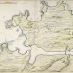
A colored plan of Le Valle dans le Clos, on the north-west coast of the island of Guernsey; shewing the soundings of the Bouche de Vale on the east, and the Pent or bay of St. Samson on the west, with various projected fortifications; drawn in 1680, by Thomas Phillips, on a scale of 600 feet to an inch.
This plan accompanies the "Observations and opinion of Capt. Christopher Gunman concerning the Harbor of Guernsey, called Bouche de Valle, given to Colonell Legge, May 21, 1680," with the examination of Pierre Du Vall and Peere Bishott; Captain Leake's account of Bouche de Valle, and the examination of Capt. William Betts.
The British Library1680

